
Places in Korea: Uijeongbu, Gyeongi Province
Basic Information
- Name: Uijongbu
- Where: Gyeongi Province
- Population: 417,915
- More Information: TripAdvisor.com

Narrative
The northern Seoul suburb of Uijongbu has long been just a sleepy farming village north of Seoul of little consequence in Korean history.
However all this would change in 1950 when it became a pivotal battlefield during the Korean War. The terrain around Uijongbu provided the last natural defensive positions before the North Korean army could reach Seoul. After the ROK Army forces lost the Battle of Uijongbu the gates to Seoul were open and the city would eventually fall only days after the North Korean invasion. Below is a picture of Uijongbu in 1950:

In the picture you can see Highway 3 which is the north-south highway running in the center of the picture and Highway43 which is on the right of the picture that is a northeast-southwest running highway. These two highways converge in Uijongbu and are the two routes the North Koreans used to capture the city during the Korean War. Interestingly enough the famous TV series M*A*S*H was based on the “4077th Mobile Army Surgical Hospital” that was stationed in Uijongbu during the Korean War.

Here is a picture that shows a US tank driving through Uijongbu during the Korean War:

After the war the city became known as a US military camp town called a “gijichon” in Korea when a large contingent of US soldiers were stationed in the city after the Korean War. Even though the town is host to US soldiers today, I don’t think anyone can claim with a straight face that Uijongbu is still a camp town considering its explosive growth that has made the city a thriving metropolitan center for Korea’s northern Gyeongi-do province. Here is a modern day Google Earth image of Uijongbu that shows how much it has grown as well as identifying the major US military installations in the city:

Read more about the US military installation in Uijongbu at the below link:
These following photographs should give everyone an indication of the explosive growth of this town. This below picture is taken from Cheonbo-san mountain that shows the US military base Camp Kyle in the foreground and Uijongbu in the distance tucked into the slopes of beautiful Dobong-san mountain in 1965:

Picture via Ottmar.
Notice how Camp Kyle is on the outskirts of the city and is surrounded by farm land. I have had people in Korea now a days ask me why the US military built their bases within Korean cities? However what these people don’t understand is the bases were originally built outside of the Korean cities, but Korea’s explosive growth over the past few decades has completely swallowed these bases.
Here is a picture I took from the same vantage point back in 2005 that shows how Camp Kyle has been completely surrounded by the city:

Camp Kyle’s front gate at this time was very dangerous because you had large slow moving military trucks trying to turn on to a fast moving highway 43 that saw heavy traffic. So it should be no surprise that Camp Kyle was one of the US military bases in Uijongbu that was shutdown in 2005.
Here is a picture from the same vantage point in 2011:
In the picture it can be seen that Camp Kyle has been completely leveled as the land is prepared for redevelopment. Here is how Camp Kyle looked when it was still open in 2005:

Camp Kyle isn’t the only place being redeveloped, just down the road from Camp Kyle is Camp Sears which was also closed out in 2005. Here is how the camp looked when it was open in 2005:

Here is how it looks in 2011 after being leveled for redevelopment:

If you look closely in the earlier 2011 picture of Uijongbu you can see that the old Camp Essayons has been leveled as well in order to construct a university hospital. Here is what the camp looked like back in 2005 when it was open:

Another USFK base Camp La Guardia has also been leveled and can be seen in the center of the below photograph also when it was open in 2005:

Camp La Guardia was really a base that needed to be closed because it was an old airfield that had been completely surrounded by the growing Uijongbu. Not all the camps in Uijongbu have been closed though. Below is a picture of Camp Red Cloud that can be seen lying at the slopes of the hills to the west of town:

Camp Stanley is the other US military base still open in Uijongbu that lies right next to the Uijongbu Prison that is the building pictured below with the blue roof:

The land where these US military camps is located is not the only place in Uijongbu being redeveloped. In the past 10 years this entire city feels like it has been redeveloped. The heart of the city is without a doubt the area around the Uijongbu Train Station. The train station used to be this old brick building that Seoul Subway Line 1 ended and passengers could transfer to the KORAIL train system to travel to locations north of Uijongbu:

Below is a picture of this location at night where Uijongbu Station is infamous to GI’s as being a place where many of the cab drivers will try to charge you hugely overpriced fees to bring you back to you camp, especially when 2ID had a curfew because they knew soldiers had no choice, but to pay the extortion:


Today commuters don’t need to change on to the KORAIL line at Uijongbu Station since Seoul Subway Line 1 has been extended all the way to Dongducheon. Additionally the station has been torn down and being redeveloped into a massive shopping center/train station:

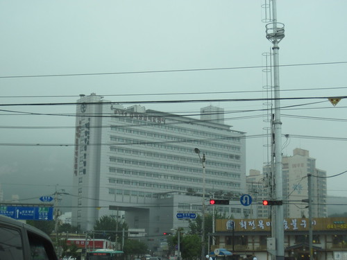
In addition to the train station the entire downtown area is being redeveloped as well. Here is a picture of downtown directly across from the east side of the train station:

The entire area has seen a number of new buildings go up that has really added to the city’s skyline:

Further into downtown away from the new buildings around the train station, the older Uijongbu of older buildings, street ajummas selling goods, crazy traffic, oblivious pedestrians, the blackmarket area, etc. can still be seen:


Here are a few pictures of the area of downtown Uijongbu to the west of the train station that was taken back in 2005. The first picture is of a wedding hall:

Just for comparison’s sake here is what a wedding hall in Uijongbu looked like in 1965:

Picture via Ottmar.
Here is the main thoroughfare in this part of town in 2005 looking east towards Uijongbu Station:

Here is the view looking west towards the city hall complex at the end of the road, which by the way is a really nice structure:

I thought the big open road and the new construction made this area of Uijongbu look really nice, but in recent years it has been spoiled by the construction of a light rail transit (LRT) system known as the U-Line:

All over Uijongbu the concrete pillars from the U-Line are a major eye sore in my opinion:

The U-Line is supposed to help relieve the major traffic congestion that plagues the city. The traffic congestion has actually gotten much better in recent years. I can remember when it took an hour to drive from Camp Stanley to Camp Red Cloud. Now it can be done in half that time during even peak traffic times. A long time friend I have in Uijongbu told me he felt the U-Line had less to do with traffic congestion and more to do with being a big public works hand out to the companies involved in its construction. I guess time will tell how popular the U-Line will be with the locals in Uijongbu. I think the biggest demographic that will use the U-Line will be students.
Finally here is a view from a hill in the neighborhood of Geumo-dong looking towards downtown Uijongbu:

This picture of downtown Uijongbu 1965 only further shows how much the city has changed since then:

To the northwest of downtown is where Camp Red Cloud pictured earlier in this posting is located. Behind Camp Red Cloud a newer neighborhood of high rise apartments has been constructed in recent years along with a very nice sports stadium:

Besides the stadium a ice rink was constructed as well:

Across the street in front of Camp Red Cloud is where older buildings remain and is the location of a small ville for US servicemembers stationed at the camp:

You can see the highly controversial Julie’s Realty is located right across the street from CRC.
The previously mentioned neighborhood of Geumo-dong is one of the fastest growing areas of the city. This is an area of the city that I know very well since I lived in this neighborhood for two years. Here is a picture of Geumo-dong viewed from the summit of Cheonbo-san mountain:

Here is what Geumo-dong looked like in 1965:

Picture via Ottmar.
I can remember 10 years ago when Geumo-dong still had farms and small businesses and since then it has all been turned into apartments and a major shopping area:

Here is a picture of Geumo-dong’s main shopping district with the city’s only Home Plus at night:

Like much of Uijongbu, Geumo-dong also has a sea of apartments:

For those that have never lived in one of these high rise Korean apartments, they are actually quite nice. My apartment was a spacious three bedroom and two bathroom apartment on the 14th floor. I really enjoyed the view from being that high up and occasionally would run up the stairs for PT instead of taking the elevator. If you are wondering how Koreans move things to the higher floors they don’t use the stairs of elevators, they instead use these lift systems that quickly move furniture and other large items into the apartments:

The Geumo-dong neighborhood is also home to St. Mary’s Hospital:
This facility really is a good hospital with a foreigner friendly staff. They have an agreement with USFK to provide medical services for US military servicemembers and their families. The wife of one my soldiers gave birth to their daughter at this hospital.
Like the rest of Uijongbu, Geumo-dong also has some areas affected by the U-Line eyesore:
Overall though the U-Line isn’t as bad as a eyesore in Geumo-dong as it is downtown. Pictured below in Geumo-dong was one of my favorite places to eat Uijongbu’s most famous dish budaejigae:

Budaejjigae is Korean for “soldier’s stew” due to the spam and other ingredients added to the dish that was introduced to the local Koreans by US GI’s:

The restaurant can be found adjacent to the old Camp Kyle. My favorite place to grab a drink was a place in Geumo-dong called Beer School:

This place had a wide selection of foreign beer and would actually issue out merit badges and diplomas to repeat customers. The owners of the establishment were very friendly to GI’s that would stop by here. Unfortunately when I went to stop by Beer School recently it was closed and was turned into a Chinese restaurant.
In Geumo-dong behind the Northern Gyeongi-do government office is a trail up a hill that provides some nice views of Uijongbu. I used to go run up the trail up this hill for PT occasionally in the morning. Here is a picture of the sunrise from this hill on one of those mornings:

Here is an example of another spectacular sunrise I was able to get a picture of in the morning:

Here are some views of the other areas of Uijongbu once again as viewed from the hill in Geumo-dong. First is a picture of the southeastern are of Uijongbu, which is where Camp Stanley is located at:

The mountain that towers over this area of the city is Suraksan mountain. Adjacent to Camp Stanley Suraksan mountain has some very nice streams that are a good place to hang out at in the summer. This section of the city is one of the most lightly populated areas where rice fields still take up just as much land as houses:

All in front of Camp Stanley are fields of rice that are worked by prisoners from the Uijongbu Prison. Also just down the road from Camp Stanley is this large Buddhist temple:

Here is a view looking towards the southwest portion of Uijongbu which is backdropped by Dobongsan mountain:

The southwestern portion of Uijongbu is sandwiched between not only Dobongsan, but Suraksan mountain as well:

The stream that runs through this area is a very popular spot for fishing:

I have never tried to go fishing in this stream because I once saw a sewage truck dumping raw waste right into this stream before:

Despite becoming a dense urban city, a nice thing about Uijongbu is how easy it is to escape the city. All around the city is wilderness areas with Dobongsan mountain which is part of Bukhansan National Park being the primary spot for people to escape the city:

Dobongsan is an extremely scenic mountain with a variety of Buddhist temples, hiking trails, and creeks to play in the water that are popular with locals.
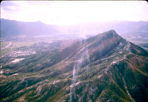
Another popular location for locals is Cheonbosan mountain located adjacent to the Geumo-dong neighborhood:

Cheonbosan is not as tall as Dobongsan, but despite this it provides better views of Uijongbu and the surrounding region than its more well known neighbor across town.
Here is how Cheonbo-san looked in 1965:

Picture via Ottmar.
Notice that in 1965 the lack of trees on the mountain as well as the absence of the twin radio towers. Another place to escape the city is the mountains behind Camp Read Cloud. This is another area I used to go running at for PT. The winding road behind the camp leads to this nice lake where I have seen plenty of locals fishing at:

There are plenty of other hills around the city that I would go hiking at and exploring no matter the weather:

Occasionally I would run into random shrines like this one pictured below:

Or even find something unusual like a deer farm on the city’s outskirts:

All in all I really enjoyed my time living in Uijongbu and always stop by and visit friends in the city whenever I am in Korea. Every time I visit it is always interesting to see how much the city has changed. It is definitely no longer a camp town and quickly becoming one of the nicest commuter suburbs of Seoul in my opinion.
If anyone has any stories to share of their time in Uijongbu please share it with everyone in the comments section.
__________________________________________________________________
- Those weren’t bran muffins, Brainiac…
11:13 am on July 25th, 2011 1
Great photos and analysis…
This statement: “I have had people in Korea now a days ask me why the US military built their bases within Korean cities? However what these people don’t understand is the bases were originally built outside of the Korean cities, but Korea’s explosive growth over the past few decades has completely swallowed these bases.” shows a great deal about the education and the mindset of the people asking the questions…
- Chris Hiler
11:57 am on July 25th, 2011 2
This page deserves repeated viewings and was a real gold mine for me since I’m trying to wrap my brain around the changes that have occurred there since my tour of duty in 1983. I still cant quite get over the general amount of development. I really had no idea before I found this ROK Drop site.
C Hiler
hiler8@gmail.com
- Chris Hiler
12:47 pm on July 25th, 2011 3
I’m wondering of all that signage on the outside of the buildings ever draws complaints from Koreans? It looks just crazy to me but I’m not sure if that’s just a cultural difference or what?
hiler8@gmail.com
C Hiler
2nd ID in 1983
- Tom Langley
1:42 pm on July 25th, 2011 4
I will say two words that old timers will know about Uijongbu & want to share some “war stories”, those words are “basket job”.
- ChipperB
5:51 pm on July 25th, 2011 5
Tom,
those two words used to be said about Sonju ri over by Paju, I believe.
- ChipperB
6:00 pm on July 25th, 2011 6
I lived in Uijongbu for 3 years in the late 90′s. I was a world class Soju drinker. My bar was the World Hof. I left in ’97 and have never been back. I enjoyed everything about Korea.
When I was at Hovey in the 80′s there was only one flashing light between Red Cloud and Casey. I will probably be going back within the next 2 years. hope I can handle it; it sure looks crowded now.
- Chris Hiler
6:30 pm on July 25th, 2011 7
ChipperB
Are you referring to this Sonju ri ? I was there in 1983
- Dennis
6:12 am on July 26th, 2011 8
When I was there in 94, they where building a tunnel through the ridge line that runs behind Camp Kyle. Just to the east of Camp Sears. There was a road over the mountain which was a narrow winding one. One weekend a few of us where bored and decided to ride bikes over the mountain for something to do. The tunnel construction looked like they where putting in a 6 lane highway in place of the small 2 lane over the top. I didn’t understand the need for it at first, but the traffic picked up and I understood it – a constant stream of slow moving trucks and cars – even on a weekend day. I also remember on the other side of the ridge, we discovered what seemed to be a farm raising dogs. It had a big Purina sign on the fence. It didn’t seem like the where raising them as purebred puppies to sell — looked more like meat production to a farm boy like me….
I also remeber the rapid construction everywhere in general. Korea obviuosly didnt have the safety standards involved in construction they way we do in the US. I remember highways with buildings sticking out into lanes and utility poles in the middle of roadways with nothing more than yellow lines painted around them. Other places where they opened sections of new highways with no merge / speedup / decelaration areas — 2 or 3 lanes just go full speed to the end onto the old 1 lane (or worse, gravel) road….every trip to Yongsan was allways an adventure….
- Nick
4:10 pm on July 26th, 2011 9
I’ve lived here in Uijeongbu since 2007 and I really liked this article. The 1950s pictures are great. Currently they are building a Shinseghe mall around Uijeongbu station that is supposed to be the largest in Korea. Bigger than the Seoul malls. Also they are adding another subway line. I think they have big plans for Uijeongbu.
- Chris Hiler
4:21 pm on July 26th, 2011 10
Nick,
Are you in the military or living there as a civilian?
SOFA?
- bob
11:39 pm on October 14th, 2011 11
Wow. Seeing Camp Sears flattened was a bit sad, but I suppose that was going to happen sooner or later. I was there from 80-81. What a great year that was. I had a really memorable time there. I couldn’t wait to leave, but I didn’t want to go so soon if that makes any sense.
- Bob
11:42 pm on October 14th, 2011 12
I’ll have to get out my G Co. 702nd year book and see which old friends I’d like to get back in contact with.
- bob
11:47 pm on October 14th, 2011 13
I recently found an author named Martin Limon that has written a good series of books about two US Army CID guys in Seoul set in the early to mid 70′s. I think anyone that was stationed over there would enjoy reading them. I did.
- Steve Jelf
11:16 pm on November 12th, 2011 14
Having been stationed there in 1965-66, I find those pictures of what has happened to the place amazing. Not many ox carts now.
- kid_wolfman
12:03 am on January 3rd, 2012 15
@ BOB 13 – I’ve read A couple of Limon’s books about a pair of CID Agents primarily working out of Yongsan Garrison. Good reads.
I just shot the link to this page to some friends so they could see the geography of my temporary “home”. AWESOME!
- Dan Babbit
5:02 am on January 6th, 2012 16
I was stationed on Camp Kyle in 1970-71 D Co 4th Maint
also at Camp Stanley
- Chris in South Korea
9:17 pm on February 8th, 2012 17
Great post – I had no idea there were so many military installations up there once upon a time.
The U-line has made some appearances on the subway maps inside the subways – have you heard anything about when the line will open?
- Stephen
11:13 pm on February 8th, 2012 18
Shinsegae Department Store is opening its Uijeongbu store in April this year.
Even Daejeon doesn’t have a Shinsegae Department Store.
- Donald R. Fox
11:25 pm on February 19th, 2012 19
I was station in the Uijeonbu area 1959-1960, 13 Trans Co (Lt Hel), H-21C Helicopter. All these pictures are a marvel…I cant recognize the area any more. Wonderful progress!
- Phil Balzano
10:18 am on March 30th, 2012 20
stationed CRC May ’64 to Feb’65. TDY@ to Albany site and Hill 651…..What happened to them????
- John Durcan
8:28 am on May 8th, 2012 21
I’m moving here in a couple of weeks (non-military) and after a week of browsing this is by far the best overall account of the city. Thank You.
- GI Korea
1:26 pm on May 8th, 2012 22
@21 – I am glad you liked the posting and enjoy your time in Uijongbu. I know that I really enjoyed living in the Guemo-dong area of the city.
- Martin Lindauer
4:07 pm on May 31st, 2012 23
Glad I found your site. I will be traveling to Korea in late June and didn’t know what to expect, having been there in 1953. You prepared me to not expect a village (Ouijonbu) or rubble (Seoul)
- James Cavel
8:44 am on June 24th, 2012 24
My name is Ronda Cavel, my husband served at 59th AVN at Camp Red Cloud from March 1966 thru April 1967. He now has stage 4 lung cancer in both lungs. I am trying to find out about any chemical spraying, just before these dates and during these dates. Also would like to find any of his buddies that served during this same time period.
- Tim Day
9:58 am on June 24th, 2012 25
What time will do to a place. Uijongbu was a small village in 1968-69. Maybe I just saw it from the base of the moutain, where our CommCenter was set up. We were north of the city, but it’s really changed.
- joe morrison
11:57 pm on July 4th, 2012 26
I was there in 1978-79-80 we are getting old now I was in mp det am looking to see if there
is anybody i know still alive.
- frank A. wells
9:29 am on August 4th, 2012 27
I was stationed at camp Essayon in 1954. The highest building in town was a 2 story bank. mostly surrounded by rice paddies and a river going through, right in front of camp essayon’s we used to was our trucks in it
- Karen/ Myung Ja
7:34 pm on September 4th, 2012 28
Hi, has anyone heard of Camp Indian in Uijongbu. This was an army base surrounded by cinder blocks. Very small camp surrounded by creek and homes. This camp is closed and overgrown with weeds now. It is near Camp Stanly set off the main road. I don’t know when it was erected but was opened at least until 1961.
- Donald R. Fox
8:10 am on September 17th, 2012 29
Hello Friends:
Reference my comment #19. When I was stationed at Camp Stanley there was a young Korean boy named “Johnny”. He stayed in the ROK barracks, I think. He was “adopted” by us soldiers. A man that was in my section Al Doucette. He wrote”As for Johnny, yes, I do remember him. I have quite a few pictures of him. He was a
nice young kid. Do you remember a Quackenbush? He was married to a Korean woman and had a little daughter. If, I’m not mistaken, he was trying to adopt Johnny. I don’t know if he did”…
Question: Does anyone remember Johnny? I pray that he is OK and maybe a citizen of the USA.
Good memories of the 13th Trans Co (H-21). God Bless, Donald R. Fox, retired, CSM
- John Andrade
1:33 am on July 29th, 2013 30
Just took a rushed 1/2 day trip from OSAN to see this city…my dad served somewhere here during the Korean War and I wanted to at least set foot in the same town since this is my first trip to Korea (2-weeks of USAFR training). I took several pictures of the blocks surrounding the train station and mall…I am really bummed that I didn’t have chance to do this research on the city before I went…your site provides a great overview and would have made my trip much more productive…since I had no idea what to expect when I got there. Let me know if you’d like pictures I took…would be happy to email them to you.
- Dolores Owen
10:01 am on August 2nd, 2013 31
I’m trying to help my boyfriend’s daughter (Angela) find her mother’s family when I came across this website. The photos of the area around Uijongbu are beautiful! Angela’s dad was stationed in Camp Stanley and her parents were married there about 1980-81. Her mother was Korean. Does anyone know how to go about getting a marriage record from that time and place?
Thanks for any help anyone can give.
Dolores.
- Dolores Owen
10:12 am on August 2nd, 2013 32
I’m trying to help my boyfriend’s daughter (Angela) find her mother’s family when I came across this website. The photos of the area around Uijongbu are beautiful! Angela’s dad was stationed in Camp Stanley and her parents were married there about 1980-81. Her mother was Korean. Does anyone know how to go about getting a marriage record from that time and place?
Thanks for any help anyone can give.
Dolores.
– See more at: http://rokdrop.com/2011/07/25/a-profile-of-uijongbu-south-korea/#comment-509526
- SFC David Hickman
6:12 pm on September 4th, 2013 33
Wonderful site. I’ve been stationed at Red Cloud almost a year. This past labor day weekend, I made my way through the trails that start behind Uijeongbu City Hall that lead to a trench system and a hiking trail. Went all the way to the top of a mountain. Not sure what part of what mountain, but it’s East by South east from Uijeongbu. Love the city and the Korean Culture.
- Jim Kenfield
8:11 am on October 2nd, 2013 34
Unbelievable!! When I was in Korea in 1953 Uijongbu was just an intersection of dusty dirt roads on the way from Seoul to Chorwon. drove through the place many times and it is hard to conceive of the progress that has been made. Guess that is why the North Korean government won’t allow their citizens to visit the South.
- dan wolfe
10:53 am on November 20th, 2013 35
Co. L, 15th Regt. 3rd Div. went into reserve just north of Uijeonbu. We desperately needed replacements. It was just a sandy plain with some wrecked homes. I can’t believe how this city evolved.
- Lia Borthwick
7:56 am on January 23rd, 2014 36
I’m so glad I found this website. I was abandoned as a baby in 1966 and recently discovered that I was found in Uijeongbu. Seeing the photos from around that time was a real eyeopener for me. The only details the adoption agency can give me is the address of the house where I was found at the age of one month. Unfortunately all other records are now lost. Luckily for me I was adopted, not by Americans, but my dad was in the British army stationed in Hong Kong. Seeing these photos and reading the comments of people who were there at the time is quite emotional for me. Thanks for the images!
One thing I would be interested if someone could tell me if Korea was still recovering from the war by then (1966) as the adoption agency told me so and that a lot of families still abandoned their babies around that time?
- Steve Jelf
8:58 am on January 23rd, 2014 37
I was there in 1965 and 1966. Yes, Korea was still recovering from the war, though I didn’t see any war-damaged buildings. That part of recovery was pretty well over. But modernization was around the corner. Farmers typically plowed with oxen, and ox carts were a common part of daily traffic along with bicycles. Riding a streetcar in Seoul I noticed that it was American and had a patent date of 1897 on the control panel. By today’s standards many people were poor, and there were a few beggars in the streets. I took a lot of pictures, and one of these years, if I live long enough, I’ll put them on my website.
- Donald R. Fox
9:26 am on January 23rd, 2014 38
Friends:
Reference # 19 and 29.
My tour was 1959-1960. Camp Stanley, 13th Trans Co (H-21). The road from Camp Stanley to Seoul was all dirt/rock. Women washed their clothes in rivers/creeks. Farmers used oxen. I never observed any tractors, etc. We had no showers/bath area for the first six months of my tour. I continue to marvel at the great improvements. It is beyond my understanding the progress in Korea and military installations also. God Bless You All,
CSM (Retired) Donald R. Fox
- Larry Lehnert
7:42 pm on January 25th, 2014 39
Does anyone have any information about the 60th transportation company at uijeongbu. I was stationed there from 1964 to 1965. I cannot remember the name of the camp. I cannot find any information about it. It’s like it never existed. It was a small camp not far from camp Red Cloud . Would like to hear from anyone who has any information and would like to share stories.
- Steve Jelf
9:14 pm on January 25th, 2014 40
Larry, we’re in the same boat. I don’t remember the name of the camp where I was stationed either. I was over there just after you, 1965-1966, in the 5760h Signal Company attached to a missile battery. I guess I need to dig up a picture and post it to see if anybody can ID the place.
- Bones
11:18 pm on January 25th, 2014 41
Larry and Steve, I’m not betting the farm on this, but it sounds like either Camp Falling Water or Camp Indian.
- Clifton
3:16 pm on April 22nd, 2014 42
Wonderful site! So happy to find it.
I was there from 62 till 67 as a defense contractor, and have visited a couple of times since. But last time was in the 70s. What changes!
Do you happen to know anything about the 696th Ammunition
Supply Point just south of CRC. I think it was called ToBongSan ASP. I would like to know if it still exists. I heard there were some terrible floods in the area, but know no more.
In 62 it was the location for the 9th Ord Detachment (Direct Support) HAWK. The 9th later became a part of the 2/71st ADA Artillery.
Any leads about the area would be very much appreciated.
Thanks. and compliments on the wonderful work.
- Rance Gillespie
3:44 pm on August 17th, 2014 43
uijeongbu ,60-62 co.c 51st signal bn.I corp. most compounds were co. size,like 55th M.P.s , 3rd L.A.S, camp red cloud was 3-4 miles away. outside our co.wire the houses [houches]were mud with thach roofs.the people were very poor,hard workers.my heart broke for the children life was hard , winter deadly for them.
i’m glad things have improved so much over there.
thank you for this great site.
rance
- Donald Eubanks
3:06 pm on August 18th, 2014 44
just browsing thru,,shocked at the improvements,was at 128th aviation co uijong-bu 73-74. nothing there then except hangers and barracks,had a good time but lost and found some very good friends,changed my life forever, skoshi-man
– See more at: http://webcache.googleusercontent.com/search?q=cache:ILamordv0HsJ:rokdrop.com/2011/07/25/a-profile-of-uijongbu-south-korea/+&cd=1&hl=en&ct=clnk&gl=us#sthash.Rb200M7G.dpuf

Wow! What an informative site! I have been researching my uncle’s military service in the Korean War. He was killed on October 2, 1950 one day before Uijongbu was liberated. I wonder if someone could help me determine the approximate location of his death from a map showing the First Marine Div. positions on that day. Thanks so much for the amazing history and description of the development of such a thriving metropolis!
Jim Lethbridge, Sussex, New Jersey, USA
#42
@Clifton
I’m not sure how to directly reply to a previous comment…
Tobongsan Compound (ASP) was in Uijeongbu (의정부) west of Uijeongbu Station and extended south between MSR3 and Tobongsan (Tobong Mountain-도봉산). It was still operational in 1985 when I arrived there.
At some point after that, it disappeared. Where it was located is now mostly like the rest of Uijeongbu (의정부) – built up beyond recognition.
There is still a small part of that area that looks like it might be used by the ROK military.
I know that Dongducheon (Tongduchon-동두천), the city where Camp Casey is located, has had a lot of flooding over the years but I haven’t heard of any serious flooding in Uijeongbu.
If you paste 37°43’1.47″N 127° 2’17.02″E in Google, it will show you the part of Tobongsan Compound that I think is still used by their military. This is the southern part of the old compound.
If ROKDrop allows URLs to be pasted, I have Tobongsan Compound (and all other Uijeongbu area camps) marked on this map:
@NC47 Lethbridge
I know it’s a old post but…
If you are talking about a map named “Pursuit of the NKPA & Capture of Uijongbu 28 Sep — 3 Oct 1950,” (https://www.koreanwar2.org/kwp2/maps/navy_pdf/INCHON_MAP25.pdf) I have that laid out in Google Earth.
The points on the map that I used to align it with today’s satellite imagery are Kimpo Airport, Yongdungpo, Seoul, Han River and Uijongbu. A lot of the old hand-drawn military maps don’t usually line up very well over a current map because they were not always drawn to scale. This map seems to line up pretty well.
The arrow marked “1/7 2 OCT” on the map starts at 37°40’42.38″N 127° 3’37.02″E and extends north to 37°42’18.06″N 127° 4’43.78″E.
The arrow ends on Suraksan (Surak Mountain-수락산). I was stationed at Camp Stanley, Korea ( 37°43’9.30″N 127° 5’45.65″E) for a few years in the mid 80s and when hiking and mountain climbing all over Suraksan.
If you happen to see this message and that isn’t the map you have, let me know where to find a copy of yours and I will try to find the location you are looking for.